Illustrations from the First Geological Survey of Arkansas
In 1857, twenty-one years after Arkansas gained statehood, the Arkansas legislature approved funding for the first geological survey of the state. Governor Elias N. Conway commissioned Dr. David Dale Owen to lead the survey beginning in 1857 to 1859 with funds of $4,800 per year, plus a salary of $1,800, and continuing from 1859 to 1860 with $6,000 per year, plus $2,500 salary. Owen was no stranger to government surveys; he also served as the State Geologist of Indiana (1837-1838) and Kentucky (1854-1857), as well as a geologist for the U.S. Government on a survey of Iowa, Minnesota, Wisconsin, and parts of Illinois and Nebraska (1839-1840, 1847-1850).

Owen commenced the Arkansas survey in Greene County with laboratory and field assistance of William Elderhorst - professor of chemistry and mineralogy at Rensselaer Polytechnic Institute, Edward T. Cox - who later would be State Geologist of Indiana, Robert Peter - chemistry professor at Transylvania University, and Charles Léo Lesquereux - paleobotanist. Owen published his first report, "First Report of a Geological Reconnaissance of the Northern Counties of Arkansas," in 1858 and followed it with "Second Report of a Geological Reconnaissance of the Middle and Southern Counties of Arkansas" in 1860. The second report was completed three days before he succumbed to illness onset from his survey in Arkansas on November 13, 1860.
Not only was David Dale Owen a geologist, but he was also an artist who illustrated the Arkansas landscape while on his survey. In both of his Arkansas reports, he included several illustrations - many in color - highlighting interesting features and scenery of Arkansas in the late 1850s:


For further reading:
Owen, David Dale, 1858, First report of a geological reconnaissance of the northern counties of Arkansas: Little Rock, Johnson & Yerkes, 287 p. (PDF link)
Owen, David Dale, 1860, Second report of a geological reconnaissance of the middle and southern counties of Arkansas: Philadelphia, C. Sherman & Son, 230 p. (PDF link)
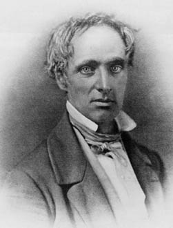
David Dale Owen
(image credit: Smithsonian Archives/Wikimedia)
Not only was David Dale Owen a geologist, but he was also an artist who illustrated the Arkansas landscape while on his survey. In both of his Arkansas reports, he included several illustrations - many in color - highlighting interesting features and scenery of Arkansas in the late 1850s:

Sugar Loaf Mountain of Searcy County, Ark.

Calico Rock on White River, Ark.

Sugar Loaf Mountain of Marion County, Ark. (possibly now in Carroll County)
Different mountain than depicted above; Geonames.org lists three "Sugarloaf Mountains", two "Sugar Loaf Mountains", and two "Sugarloaf Knobs" in Arkansas

Prominent mass of sandstone in Carroll County (now either Carroll or Boone County)

Mammoth Spring of Fulton County, Ark. (now Mammoth Springs State Park)

Rock house on Cave Creek, Newton County

Short Mountain from the Haguewood Prairie (near Paris, Logan County)

Magazine Mountain from Stone Point in the Grand Prairie of Franklin (now Logan) County

Cortes Mountain from Hodges Prairie, eastern termination of the Sugar-Loaf Range, Sebastian County (possibly now Sebastian or Scott County)

Natural abutments of the white novaculite rock on the Ouachita River at Rockport, Hot-Spring County, Arkansas

Sunk lands looking north from the Deep Landing (likely now in or near the St. Francis Sunken Lands Wildlife Management Area in northeast Arkansas)
For further reading:
Owen, David Dale, 1858, First report of a geological reconnaissance of the northern counties of Arkansas: Little Rock, Johnson & Yerkes, 287 p. (PDF link)
Owen, David Dale, 1860, Second report of a geological reconnaissance of the middle and southern counties of Arkansas: Philadelphia, C. Sherman & Son, 230 p. (PDF link)


Comments
Post a Comment