The Norphlet Crater: When A Good Well Goes Bad
Hidden in the woods of Union County, Arkansas, a large unassuming sinkhole housing a small pond called the Norphlet Crater was added to the National Register of Historic Places in 2008. Although it's easy to overlook, this hole in the ground has quite a story to tell about the early days of the oil and gas industry in Arkansas and a gas well that could not be tamed.

Topographic map view of Norphlet Crater
In 1922, two years following the Hill No. 1 gas well drilled by Constantine Oil and Refining Company near El Dorado, Arkansas, oil and gas
production in the area expanded dramatically and El Dorado became the hub for
the petroleum industry in Arkansas. Small independent oil companies and major
companies with internationally recognized names, such as Shell and Standard Oil,
were all drilling in Union County, Arkansas. In the pine covered hills and
farmland about eight miles northwest of El Dorado, near the small town of
Norphlet, a cotton field[1] on a farm owned by Mr. Jesse T. Murphy
(in Sec. 8 T.16S., R.15W.)[2] would cause the quiet town to become
the newest boomtown almost overnight. Unbeknownst to Mr. Murphy, his farm was
located on top of a geological structure that would later be known as the
Norphlet Dome. This dome acted as a structural trap for oil and gas that was
largely untapped[1]. In the spring of 1922, the Oil Operators’
Trust Company leased a plot of land on Mr. Murphy’s farm to drill the Murphy
No. 1 well (also called the Anderson-Murphy No. 1 and John L. Anderson-Murphy
No. 1) with drilling contractor John L. Anderson[3].
On Sunday, May 14, the rig crew finished drilling to 2,025
feet in the Cretaceous age Nacotoch Sand[2,4]. After reaching total
depth, they began pulling the drill pipe out of the borehole. At about eight
o’clock that evening[1], when they had all but 200 feet of pipe out
of the hole, they received a gas kick (a large volume of gas rising in the
borehole). The rising gas roared with the sound of a modern-day jet engine that
could be heard over two miles away[2] and “[d]rilling crews…up to a
quarter mile away claimed they had to plug their ears”[1]. The
pressure of the gas pushed the remaining drill pipe upwards damaging the
derrick. The roughnecks, hearing and feeling the rumble of the gas, dashed to
refuge. Working in the derrick was another roughneck who grabbed ahold of a guy
wire leashing the top of the derrick to the ground and slid to safety "just
as the drill stem was ejected from the well"[4]. They were left
to watch the derrick collapse, save "a small section, which was held up by
the guy wires"[4]. For the remainder of the day, the rig crew
was resigned to leave the well to continue blowout and evaluate the remaining
equipment.

A geyser of fluids
bursting of the destroyed derrick of the Murphy No. 1 well
(image credit: The Arkansas
Gazette[5])
The next day, the well continued to blowout with no hope of
controlling it[6], releasing an initial estimate of 65 Mmcf/d
(million cubic feet per day) to 75 Mmcf/d of dry gas, but was later estimated at nearly 100 Mmcf/d[2,4,6,7]. This new petroleum field was named
the El Dorado North Pool and attracted sudden interest in the industry and among the local residents. The road leading to the
well, touted as "the best road in the county"[2] was
"lined with cars all day and hundreds visited the scene"[6].
Unlike the Constantine Hill No. 1 well from two years prior, this well was not
blowing water, only gas, dust, and rocks. One reporter said that "for
several miles around the well the ground is covered with a fine slate-colored
dust" and on several occasions, head-sized stones were ejected from the
well[6]. There was a concern "that before morning the wind will
change or the atmosphere will become more dense, causing the gas to hug the ground and that the big well will be ignited"[6]. However, the unexpected problems of "craters" was a sudden concern, reminiscent of the Hill No. 1 well, becoming even more of a spectacle for the locals, who even set up refreshment stands near the crater[1]. One witness said, “when I first saw this crater…I thought the devil was coming. I thought the Lord was trying to tell us something in a big way. It was just bubbling and carrying on terrible”[1]. At around seven or eight o'clock that evening[4,6], "several visitors were standing on the brink of the biggest geyser"[6], just "[o]ne of the numerous craters which sprung up about 200 yards [north] from the wild Anderson-Murphy gasser"[6]. Five minutes later, the gas ignited from friction, "setting fire to several other
similar craters in the immediate vicinity" and "[a]t 10 o'clock there
were half a dozen craters all nearly connected, throwing burning gas as high as
100 feet in the air"[4,6]. Fortunately, those standing nearby
escaped unharmed[6].
The next morning, on May 16, the situation was not
improving. A 200-foot diameter crater formed nearby, "numerous geysers
[were] forming on all sides of the well," and "[t]he roar of the
flames [could] be heard for miles"[4]. "[S]hortly after 5
o'clock" in the morning, the well ignited "from the surrounding small
craters"[8]. Estimates of the amount of gas released increased from
100 MMcf/d to about 150 Mmcf/d[8]. The flames were reaching about
300 feet into the air and "several miles around was almost as light as day"[8].
A reporter for the Monroe News-Star said that "even though the well is
eight miles north of El Dorado, at 12 o'clock last night the blowing could
easily be heard from the court house square"[4]. Local
residents said that their water wells were now producing gas and several people
"have been compelled to move on account of geysers forming near their
homes"[4]. The rig crew was powerless in controlling the well
and was left to hope that either the sand blown out of the well will extinguish
it, or the recent caving of the ground around the well will snuff out the fire[8].
The sand was providing some help in putting out the fire with large sand drifts, at least until a pocket of gas would be released and the blaze would again flare up[8].

Smoke rising from the
raging fire at the Murphy No. 1 well
(image credit:
Arkansas Museum of Natural Resources via Nat’l Register Application Form[1])
Hope was restored the following day, when caving around the
craters nearly extinguished the fires[7]. The largest crater,
"possibly 350 feet across"[9], would release gas and
re-ignite several times, and about a dozen other craters in the vicinity were
erupting mud and gas[9]. It was thought "that all craters will
be dead before morning"[9], however, the crater wouldn't go so
quietly. The boiler used for the Murphy No. 1 “topplled (sic) into the
crater and [was] spinning around in the hole like a top”[10]. Dust
and rocks continued to erupt sporadically over the next few days, even
"blowing at intervals of 20 minutes"[11], but was said to
be "growing weaker"[11,12]. During this time, oilfield
workers and representatives of oil and gas companies arrived on each train that
stopped in El Dorado and Norphlet crowding the hotels[5]. Deals for
lease acreage to drill more oil and gas wells were being made constantly
including "at least four wells...in the vicinity" of the Murphy No. 1[13].
Lease deals went for premium prices that approached $200 per acre (appx. $3,070
in 2019)[14], while real estate deals in Norphlet also fetched prices
not before seen in what was described as "one of the quietest [towns] in
the county"[15]. A store was reported to charge rent at $150 per
month, a significant increase from the $7 per month it used to charge[15].
New buildings, temporary and permanent, were being raised all around town to
accommodate the boom in business[15].

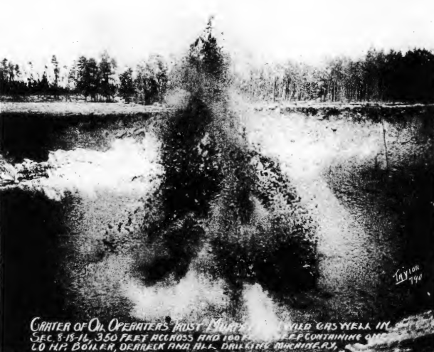
Giant crater from the Murphy No. 1 well
(image credit: Arkansas Geological Survey)
At about two o'clock on May 22, friction once again ignited
the gas in the largest crater while ejecting water, mud, gas, rocks, and even
"oil in considerable quantities"[14]. Spectators standing
nearby escaped injury, although two bystanders had their hair singed[14].
The fire was extinguished early on the morning of May 25, but stubbornly
re-ignited[16]. At this point, the state of Arkansas was starting to
get involved in the situation and it was reported that it was probable “that
the state will be forced to take over"[16]. Concerns were also
raised about the expanding crater approaching a nearby African-American
cemetery that dated back to the 1840s (presumably Hicks Cemetery), putting
graves at risk of collapsing into the crater[15].
On May 30, the giant crater was continuing to spew gas and
rocks, "but is nearly dead"[17]. At least that was what
they continued to hope for. On June 19, the newspaper stated that it was still
"blowing strong and occasionally throwing mud high into the air...When the
crater makes a heavy spurt and tons of mud are thrown into the air, the impact
of the mud striking the bottom of the crater shakes the ground for several
hundred feet. Caving continues, but not as frequently as at first"[18].
While the Murphy No. 1 was running wild and ablaze, the Oil
Operators Trust Company drafted plans to drill a second well nearby, the Murphy
No. 2 (three-eighths of a mile southwest of Murphy No. 1 in Sec. 8, T.16S.,
R.15W.), also drilled by the same contractor, John L. Anderson[19].
At five o'clock in the afternoon on June 21, the well was drilled to a depth of
890 feet (12.5-inch surface casing was set at 600 feet) and, like a recurring
nightmare, they were hit with a gas kick. Gas and sand were shot out of the
derrick like a geyser, going 75 feet higher than then derrick[19].
There was deep concern that the derrick was again being damaged[19],
but the drillers thought the derrick could withstand the punishment[20].
Two nights later, a 15-foot wide crater developed around the Murphy No. 2 well,
although sand plugged off the well, it "may break out again at any
time"[21].
Eruption of mud and gas in the Murphy No. 1 crater
(image credit: Arkansas Museum of Natural Resources via Nat’l Register Application Form[1])
On June 26, the Murphy No. 1 geyser died off, but at the
same time, the Murphy No. 2 came to life. The blowout from the No. 2 well was
reported "to rival the No. 1 crater" with an ever-growing 50-foot
wide crater[22]. Two days later, the Murphy No. 2 geyser caught fire “either by
lightning or friction, during an electric and rain storm this afternoon, and is
burning with apparently greater brilliance than the first crater”[23].
The No. 2 well continued to be problematic for the operators for several weeks
as a “veritable mud volcano”[24], eventually the fire was extinguished, but it continued to erupt mud and gas well into November[25]. Throughout this
entire ordeal, the Oil Operators’ Trust Company had hoped to salvage a productive
well, however, they reluctantly announced on July 11 that the No. 1 well had
lost “five or six billion cubic feet of gas” and was going to be abandoned "as a vast crater surrounds the spot" that spouted gas[26].

The Norphlet Crater
as seen today. A glimmer of water at the bottom of the crater can be seen
through the overgrown vegetation (image credit: Wikimedia)
Today, the giant crater is overgrown with vegetation and
a small pond at the bottom collects oil that seeps to the surface[1].
The rim of the crater is surrounded by a chain link fence along Firetower Rd.,
¾ mile north of the Baugh St. junction (GPS coordinates: 33.341538, -92.668666;
Google Maps link)[1]. The site is owned by the county and was added
to the National Register of Historic Places in 2008[1]. The Oil
Operators’ Trust Company and other oil companies drilled several other wells in
the area. Some were problematic and experienced blowouts, and some rare ones caught fire, but they largely went according to plan and were productive. The Norphlet Dome is not actively produced
today, but several other oil and gas fields, collectively known as the Smackover Field, in Union County continue to be
productive. In 1923, the Arkansas Geological Survey was re-established in response to the expansion of the oil and gas industry in Arkansas. In 1939, the Arkansas Oil and Gas Commission was formed to regulate
the oil and gas industry, including prevention of wasted gas and local disruptions
such as what was experienced from the Murphy No. 1 well[1].
Sources:
1, National Register of Historic Places Registration Form,
U.S. Department of the Interior, National Park Service, 24 January 2008, Site
#UN0349.
2, "Mammoth gasser in new territory," Arkansas
Gazette, Little Rock, Arkansas, p. 1, 15 May 1922, print.
3, "New tests planned for area northwest El Dorado
pool," The Oil Weekly, Houston, Texas, p. 48, 3 June 1922, print
4, "Crater hundreds of feet wide blown out at wild
Murphy well and geysers are forming around it," The Monroe News-Star,
Monroe, Louisiana, p. 1, 16 May 1922, print.
5, "Wild gas well is nearly quiet," Arkansas
Gazette, Little Rock, Arkansas, p. 11, 19 May 1922, print.
6, "Flames surround big wild gasser," Arkansas
Gazette, Little Rock, Arkansas, p. 1, 16 May 1922, print.
7, "Gas flames extinguished," The Monroe
News-Star, Monroe, Louisiana, p. 3, 17 May 1922, print.
8, "Great gas well is mass of flame," Arkansas
Gazette, Little Rock, Arkansas, p. 1, 17 May 1922, print.
9, "Fire snuffed out by falling sand," Arkansas
Gazette, Little Rock, Arkansas, p. 13, 18 May 1922, print.
10, "Burning gasser flashes out as result of
cave," The Monroe News-Star, Monroe, Louisiana, p. 12, 19 May 1922, print.
11, "Ready for the bailer," Arkansas Gazette,
Little Rock, Arkansas, p. 13, 20 May 1922, print.
12, "Expects well today," Arkansas Gazette,
Little Rock, Arkansas, p. 3, 22 May 1922, print.
13, "El Dorado has a successful week," Arkansas
Gazette, Little Rock, Arkansas, p. 48, 21 May 1922, print.
14, "Great gas well is on fire again," Arkansas
Gazette, Little Rock, Arkansas, p. 1, 23 May 1922, print.
15, "Operations move to north field," Arkansas
Gazette, Little Rock, Arkansas, p. 12, 28 May 1922, print.
16, "Gasser ceases burning," Arkansas Gazette,
Little Rock, Arkansas, p. 12, 26 May 1922, print.
17, "Oil at deep level," Arkansas Gazette, Little
Rock, Arkansas, p. 9, 31 May 1922, print.
18, "Gasser still blowing," Arkansas Gazette,
Little Rock, Arkansas, p. 11, 20 June 1922, print.
19, "Shallow well is in at El Dorado," Arkansas
Gazette, Little Rock, Arkansas, p. 3, 22 June 1922, print.
20, "Well still blowing," Arkansas Gazette,
Little Rock, Arkansas, p. 14, 23 June 1922, print.
21, "May open a new pool at El Dorado," Arkansas
Gazette, Little Rock, Arkansas, p. 5, 24 June 1922, print.
22, "New well a producer," Arkansas Gazette,
Little Rock, Arkansas, p. 10, 27 June 1922, print.
23, "Another crater fired," Arkansas Gazette,
Little Rock, Arkansas, p. 3, 29 June 1922, print.
24, "Much drilling in Union East Field," Arkansas
Gazette, Little Rock, Arkansas, p. 9, 16 July 1922, print.
25, "Clark and Melat have new gusher," Arkansas
Gazette, Little Rock, Arkansas, p. 15, 24 Nov 1922, print.
26, "News of world's great gas area," The Monroe
News-Star, Monroe, Louisiana, p. 2, 11 July 1922, print.


Comments
Post a Comment