Maps Below Our Feet
About four years ago I ran across a website called Macrostrat.org, a website that started from the University of Wisconsin to compile stratigraphic data into a searchable database. While browsing their site, I saw the most beautiful geologic map. Don't get me wrong, there are great geologic maps that have been published, but this one struck a chord with me.

Painted in the standard geologic colors, but with an earthy hue, was the surficial geology of the continental United States, northern Mexico, southern Canada, and the oceans. No borders between countries or states were visible, except for a couple of inexplicable odd lines along Michigan and Mexico that just happened to render. It's just geology. The zoom setting I had it on restricted the details to what are visble on a national scale. Not too generalized; not too specific. It looked as if it were a piece of abstract art with hints of Jackson Pollock evident in the Basin and Range province. I immediately thought that this needs to be done as a painting or even a mural. I've yet to paint this, but I saved the image for future inspiration.
Fast forward to this weekend and I ran across another site that shows the US in ways that we aren't used to:
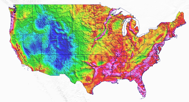
The Bouguer (pronounced Boo-gay') gravity anomaly map is a map of the Earth's gravity, but corrected for the height at which it is measured and the attraction of the terrain (free-air , terrain, and geoid corrections). This can be broadly interpreted to indicate changes in the Earth's crust (low-density felsic crust versus high-density mafic crust). The Precambrian Midcontinet Rift (https://eos.org/features/new-insights-into-north-americas-midcontinent-rift) is seen in pink in Minnesota and Iowa. The Cambrian Southern Oklahoma Aulacogen is seen in pink along the Red River. Both ancient rift systems have been filled with dense mafic rocks. While the Rocky Mountains are a thick accumulation of low-density felsic rocks, resulting in the blue colors.

Isostatic gravity anomaly maps are another way illustrate the gravity of the Earth by subtracting the gravitational effect of low-density mountain roots below areas of high topography (more about gravity measurements).

The magnetic anomaly map displays areas that have high or low relative magnetic properties. These could be areas with high iron contents such as lead-zinc ore deposits or mafic rocks. Some tectonic events seen in the above gravity maps are (Midcontinent Rift and Southern Oklahoma Aulacogen) also seen here.


Aeroradiometric map showing the relative quanitites of uranium, thorium, and potassium at the surface. Uranium and thorium are generally more concentrated in shale or clay rocks, while potassium is more concentrated in rocks with high quantities of orthoclase feldspar (e.g. arkose sandstone or some felsic rocks).
Unfortunately, I don't remember enough about geophysics to adequately describe the gravity and magnetic anomaly maps, but I dig these depictions of the US (pun intended).


Comments
Post a Comment